
Grand Pacific Walk, Austinmer
Consultation has concluded
As part of our commitment to improve cycling links throughout Wollongong, we are proposing to build a 2.5m wide shared user path in Austinmer. It will run alongside the coastal roads from Herah’s Beach to Headlands Hotel.
This proposed section of the Grand Pacific Walk will make it safer for cyclists and pedestrians to ride and walk in Austinmer. These upgrades are an important connecting link in the Wollongong cycling network being developed as part of the Wollongong Cycling Strategy 2030.
This project is funded by the NSW Government under the Get NSW Active Program 2022/23.
Check out the draft plans here.
For more information and to share your thoughts on the Grand Pacific Walk in Austinmer.
You can find out more by reading the FAQs and viewing the plans. To make comment, you can:
- Complete the online survey
- Ask us a question
- Emailing engagement@wollongong.nsw.gov.au
- Phoning (02) 4227 7111
- Writing to The Engagement Team, Wollongong City Council, Locked Bag 8821 WOLLONGONG DC NSW 2500
Accessibility, mobility or language assistance
If you’re d/Deaf, hard of hearing or have a speech or language difficulty, you can contact us through the National Relay Service. If you need an interpreter, you can contact us through the Translating and Interpreting Service on 131 450. You’ll need to provide our phone number 02 4227 7111 for either service. If you would like to attend the information sessions and have accessibility or mobility requirements, please let us know how we can support your attendance. We can also arrange for an interpreter to come along to help residents who have difficulty communicating in English. To arrange support, please contact engagement@wollongong.nsw.gov.au
Join the conversation
Share your feedback with the project team by 14 December 2023
Submissions become public documents and may be viewed by other persons on request. Please read Council's Privacy Policy before submitting your feedback.
Do you have any questions about the Grand Pacific Walk Austinmer? Let us know in the box below.
-
Share Hi there, this plan sounds wonderful. I’m assuming more pedestrian crossings over Lawrence Hargrave drive will be included? There are literally no safe ways to get across that road except at Austi school lights. It’s so dangerous. The plan is flawed if this isn’t part of it. on Facebook Share Hi there, this plan sounds wonderful. I’m assuming more pedestrian crossings over Lawrence Hargrave drive will be included? There are literally no safe ways to get across that road except at Austi school lights. It’s so dangerous. The plan is flawed if this isn’t part of it. on Twitter Share Hi there, this plan sounds wonderful. I’m assuming more pedestrian crossings over Lawrence Hargrave drive will be included? There are literally no safe ways to get across that road except at Austi school lights. It’s so dangerous. The plan is flawed if this isn’t part of it. on Linkedin Email Hi there, this plan sounds wonderful. I’m assuming more pedestrian crossings over Lawrence Hargrave drive will be included? There are literally no safe ways to get across that road except at Austi school lights. It’s so dangerous. The plan is flawed if this isn’t part of it. link
Hi there, this plan sounds wonderful. I’m assuming more pedestrian crossings over Lawrence Hargrave drive will be included? There are literally no safe ways to get across that road except at Austi school lights. It’s so dangerous. The plan is flawed if this isn’t part of it.
Jane Morris asked 5 months agoLawrence Hargrave Drive is a state-owned road and therefore Council has no authority to add pedestrian crossings on this road. Council has and will continue to work with Traffic for NSW to advocate for a safe pedestrian crossings along Lawrence Hargrave Drive.
-
Share When will we have more than a gravel path between Headlands Ave and Sharkey Beach? It is still washed out after the 2021 flooding, and WCC have done nothing but dump gravel there every so often, it is downhill, off-camber and has severe cracking that is really dangerous to anyone. on Facebook Share When will we have more than a gravel path between Headlands Ave and Sharkey Beach? It is still washed out after the 2021 flooding, and WCC have done nothing but dump gravel there every so often, it is downhill, off-camber and has severe cracking that is really dangerous to anyone. on Twitter Share When will we have more than a gravel path between Headlands Ave and Sharkey Beach? It is still washed out after the 2021 flooding, and WCC have done nothing but dump gravel there every so often, it is downhill, off-camber and has severe cracking that is really dangerous to anyone. on Linkedin Email When will we have more than a gravel path between Headlands Ave and Sharkey Beach? It is still washed out after the 2021 flooding, and WCC have done nothing but dump gravel there every so often, it is downhill, off-camber and has severe cracking that is really dangerous to anyone. link
When will we have more than a gravel path between Headlands Ave and Sharkey Beach? It is still washed out after the 2021 flooding, and WCC have done nothing but dump gravel there every so often, it is downhill, off-camber and has severe cracking that is really dangerous to anyone.
simonpinn asked 5 months agoThe Grand Pacific Walk, Coledale design process is currently underway. This project extends from Headland Avenue north to Coledale Public School and will tie in to the recently completed Coledale Beach parking area. This will include a design for a pathway to Sharky's Beach.
Community consultation for this project will begin in 2024.
-
Share The stretch between Little Austinmer Ave and Headlands Ave is the most direct route, do you really expect school kids, commuters and well anyone who isn't just out for a stroll to take a detour down a one-way road that is often parked out, over a blind crescent and past Heandlands Hotel (where people speed around trying to find a carpark) instead of just following the current path? I understand it's narrow, so maybe the width needs to be reduced for this section, would be a much better experience. on Facebook Share The stretch between Little Austinmer Ave and Headlands Ave is the most direct route, do you really expect school kids, commuters and well anyone who isn't just out for a stroll to take a detour down a one-way road that is often parked out, over a blind crescent and past Heandlands Hotel (where people speed around trying to find a carpark) instead of just following the current path? I understand it's narrow, so maybe the width needs to be reduced for this section, would be a much better experience. on Twitter Share The stretch between Little Austinmer Ave and Headlands Ave is the most direct route, do you really expect school kids, commuters and well anyone who isn't just out for a stroll to take a detour down a one-way road that is often parked out, over a blind crescent and past Heandlands Hotel (where people speed around trying to find a carpark) instead of just following the current path? I understand it's narrow, so maybe the width needs to be reduced for this section, would be a much better experience. on Linkedin Email The stretch between Little Austinmer Ave and Headlands Ave is the most direct route, do you really expect school kids, commuters and well anyone who isn't just out for a stroll to take a detour down a one-way road that is often parked out, over a blind crescent and past Heandlands Hotel (where people speed around trying to find a carpark) instead of just following the current path? I understand it's narrow, so maybe the width needs to be reduced for this section, would be a much better experience. link
The stretch between Little Austinmer Ave and Headlands Ave is the most direct route, do you really expect school kids, commuters and well anyone who isn't just out for a stroll to take a detour down a one-way road that is often parked out, over a blind crescent and past Heandlands Hotel (where people speed around trying to find a carpark) instead of just following the current path? I understand it's narrow, so maybe the width needs to be reduced for this section, would be a much better experience.
simonpinn asked 5 months agoPedestrians are not required to detour and can continue on the pedestrian pathway along Lawrence Hargrave Drive between Little Austinmer Lane and Headlands Avenue. Council will be upgrading sections of this pathway as some areas along this stretch are in disrepair.
Cyclists will be required to continue on the shared pathway on Yuruga Street and Little Austinmer Lane.
-
Share Has council consulted with emergency services on the impact of accessing houses Headlands Ave, Yuruga St and Little Austinmer Lane with an expected increase in foot and bike traffic? on Facebook Share Has council consulted with emergency services on the impact of accessing houses Headlands Ave, Yuruga St and Little Austinmer Lane with an expected increase in foot and bike traffic? on Twitter Share Has council consulted with emergency services on the impact of accessing houses Headlands Ave, Yuruga St and Little Austinmer Lane with an expected increase in foot and bike traffic? on Linkedin Email Has council consulted with emergency services on the impact of accessing houses Headlands Ave, Yuruga St and Little Austinmer Lane with an expected increase in foot and bike traffic? link
Has council consulted with emergency services on the impact of accessing houses Headlands Ave, Yuruga St and Little Austinmer Lane with an expected increase in foot and bike traffic?
KA asked 6 months agoCouncil has compared this project to projects with similar access and increased bike and foot traffic and believe there will be minimal effect on access.
-
Share How will council grounds team access the large flat grassy area at the northern end of Little Austinmer Beach. They currenty take the tractor/slasher and ride on mowers down the hill off the footpath to mow the 100mx 10m or so area? There is no access from the Bells Pt track as WCC have closed it and the creek/drain to the north also limits access. have you consulted with your own staff as to how they will get access to maintain the area? on Facebook Share How will council grounds team access the large flat grassy area at the northern end of Little Austinmer Beach. They currenty take the tractor/slasher and ride on mowers down the hill off the footpath to mow the 100mx 10m or so area? There is no access from the Bells Pt track as WCC have closed it and the creek/drain to the north also limits access. have you consulted with your own staff as to how they will get access to maintain the area? on Twitter Share How will council grounds team access the large flat grassy area at the northern end of Little Austinmer Beach. They currenty take the tractor/slasher and ride on mowers down the hill off the footpath to mow the 100mx 10m or so area? There is no access from the Bells Pt track as WCC have closed it and the creek/drain to the north also limits access. have you consulted with your own staff as to how they will get access to maintain the area? on Linkedin Email How will council grounds team access the large flat grassy area at the northern end of Little Austinmer Beach. They currenty take the tractor/slasher and ride on mowers down the hill off the footpath to mow the 100mx 10m or so area? There is no access from the Bells Pt track as WCC have closed it and the creek/drain to the north also limits access. have you consulted with your own staff as to how they will get access to maintain the area? link
How will council grounds team access the large flat grassy area at the northern end of Little Austinmer Beach. They currenty take the tractor/slasher and ride on mowers down the hill off the footpath to mow the 100mx 10m or so area? There is no access from the Bells Pt track as WCC have closed it and the creek/drain to the north also limits access. have you consulted with your own staff as to how they will get access to maintain the area?
Neil B asked 6 months agoAs part of this project Council is investigating access for mowers and trucks as well as pedestrians at Little Austinmer Beach.
-
Share There is a dangerous blind crest on Yuruga st with cars often parking on both sides of the Headlands ave driveway even though it has a No Parking sign. This has already been the site of many near misses and recently a road rage incident leading to a hospital attendance. Adding more bikes and pedestrians may increase the risk of an accident or incident here. How does council plan to mange this? on Facebook Share There is a dangerous blind crest on Yuruga st with cars often parking on both sides of the Headlands ave driveway even though it has a No Parking sign. This has already been the site of many near misses and recently a road rage incident leading to a hospital attendance. Adding more bikes and pedestrians may increase the risk of an accident or incident here. How does council plan to mange this? on Twitter Share There is a dangerous blind crest on Yuruga st with cars often parking on both sides of the Headlands ave driveway even though it has a No Parking sign. This has already been the site of many near misses and recently a road rage incident leading to a hospital attendance. Adding more bikes and pedestrians may increase the risk of an accident or incident here. How does council plan to mange this? on Linkedin Email There is a dangerous blind crest on Yuruga st with cars often parking on both sides of the Headlands ave driveway even though it has a No Parking sign. This has already been the site of many near misses and recently a road rage incident leading to a hospital attendance. Adding more bikes and pedestrians may increase the risk of an accident or incident here. How does council plan to mange this? link
There is a dangerous blind crest on Yuruga st with cars often parking on both sides of the Headlands ave driveway even though it has a No Parking sign. This has already been the site of many near misses and recently a road rage incident leading to a hospital attendance. Adding more bikes and pedestrians may increase the risk of an accident or incident here. How does council plan to mange this?
KA asked 6 months agoBy designing a safe space for pedestrians and cyclists, as well as traffic calming measures, the shared pathway will help reduce incidents.
-
Share In summer time in particular, these local roads are already congested with traffic attending Headlands Hotel, the boat ramp, the tennis courts, weddings at Little Austinmer beach and two unpatrolled beaches. Has council completed a traffic survey to determine if these streets are appropriate and safe to take increased use? on Facebook Share In summer time in particular, these local roads are already congested with traffic attending Headlands Hotel, the boat ramp, the tennis courts, weddings at Little Austinmer beach and two unpatrolled beaches. Has council completed a traffic survey to determine if these streets are appropriate and safe to take increased use? on Twitter Share In summer time in particular, these local roads are already congested with traffic attending Headlands Hotel, the boat ramp, the tennis courts, weddings at Little Austinmer beach and two unpatrolled beaches. Has council completed a traffic survey to determine if these streets are appropriate and safe to take increased use? on Linkedin Email In summer time in particular, these local roads are already congested with traffic attending Headlands Hotel, the boat ramp, the tennis courts, weddings at Little Austinmer beach and two unpatrolled beaches. Has council completed a traffic survey to determine if these streets are appropriate and safe to take increased use? link
In summer time in particular, these local roads are already congested with traffic attending Headlands Hotel, the boat ramp, the tennis courts, weddings at Little Austinmer beach and two unpatrolled beaches. Has council completed a traffic survey to determine if these streets are appropriate and safe to take increased use?
KA asked 6 months agoWith the improvement to pathways, Council is aiming to create an accessible place for locals and visitors to walk and ride safely, which may lead to a decrease in traffic congestion.
-
Share To continue along Lawrence Hargrave Dr is a direct route, crossing 6 driveways and negotiating 1 road crossing. The proposed route is circuitous, crosses10 driveways with one being the access for 4 dwellings, so 14 in total, with 2 road crossings. This makes the proposed cycleway less safe. Can you comment on LH Dr as an alternative? I understand there appears to be a single pinchpoint at 63 LH DR which is not as bad as some that have been negotiated elsewhere. The drainage issue which undermines the lane could be addressed at the same time as the cycleway if it went via LH Dr. on Facebook Share To continue along Lawrence Hargrave Dr is a direct route, crossing 6 driveways and negotiating 1 road crossing. The proposed route is circuitous, crosses10 driveways with one being the access for 4 dwellings, so 14 in total, with 2 road crossings. This makes the proposed cycleway less safe. Can you comment on LH Dr as an alternative? I understand there appears to be a single pinchpoint at 63 LH DR which is not as bad as some that have been negotiated elsewhere. The drainage issue which undermines the lane could be addressed at the same time as the cycleway if it went via LH Dr. on Twitter Share To continue along Lawrence Hargrave Dr is a direct route, crossing 6 driveways and negotiating 1 road crossing. The proposed route is circuitous, crosses10 driveways with one being the access for 4 dwellings, so 14 in total, with 2 road crossings. This makes the proposed cycleway less safe. Can you comment on LH Dr as an alternative? I understand there appears to be a single pinchpoint at 63 LH DR which is not as bad as some that have been negotiated elsewhere. The drainage issue which undermines the lane could be addressed at the same time as the cycleway if it went via LH Dr. on Linkedin Email To continue along Lawrence Hargrave Dr is a direct route, crossing 6 driveways and negotiating 1 road crossing. The proposed route is circuitous, crosses10 driveways with one being the access for 4 dwellings, so 14 in total, with 2 road crossings. This makes the proposed cycleway less safe. Can you comment on LH Dr as an alternative? I understand there appears to be a single pinchpoint at 63 LH DR which is not as bad as some that have been negotiated elsewhere. The drainage issue which undermines the lane could be addressed at the same time as the cycleway if it went via LH Dr. link
To continue along Lawrence Hargrave Dr is a direct route, crossing 6 driveways and negotiating 1 road crossing. The proposed route is circuitous, crosses10 driveways with one being the access for 4 dwellings, so 14 in total, with 2 road crossings. This makes the proposed cycleway less safe. Can you comment on LH Dr as an alternative? I understand there appears to be a single pinchpoint at 63 LH DR which is not as bad as some that have been negotiated elsewhere. The drainage issue which undermines the lane could be addressed at the same time as the cycleway if it went via LH Dr.
RS asked 6 months agoCouncil did investigate extending the shared pathway along Lawrence Hargrave Drive, rather than on Little Austinmer Lane. Due to the specific constraints of this area (including pinch points and drainage infrastructure) the decision was made for the shared path to travel along Little Austinmer Lane and Yuruga Street to allow pedestrians to easily access the northern end of Little Austinmer Beach. Sections of Lawrence Hargrave Drive past Little Austinmer Lane will still be upgraded, but not as a 2.5m wide shared pathway
-
Share Why is the cycleway not just going up Lawrence Hargrave drive at Little Austinmer Beach? It seems far more dangerous to have it divert down a one-way lane and then over the hill at Yuruga Street? There are already so many issues with near accidents in that lane on Facebook Share Why is the cycleway not just going up Lawrence Hargrave drive at Little Austinmer Beach? It seems far more dangerous to have it divert down a one-way lane and then over the hill at Yuruga Street? There are already so many issues with near accidents in that lane on Twitter Share Why is the cycleway not just going up Lawrence Hargrave drive at Little Austinmer Beach? It seems far more dangerous to have it divert down a one-way lane and then over the hill at Yuruga Street? There are already so many issues with near accidents in that lane on Linkedin Email Why is the cycleway not just going up Lawrence Hargrave drive at Little Austinmer Beach? It seems far more dangerous to have it divert down a one-way lane and then over the hill at Yuruga Street? There are already so many issues with near accidents in that lane link
Why is the cycleway not just going up Lawrence Hargrave drive at Little Austinmer Beach? It seems far more dangerous to have it divert down a one-way lane and then over the hill at Yuruga Street? There are already so many issues with near accidents in that lane
GaryHardie asked 6 months agoThere is limited space in this area to fit a shared path due to the bank that supports the road. The project will be doing works within the laneway to make it safer for cyclist.
-
Share After having viewed the Grand Pacific Walk - Austinmer Consultation Plan the answer to the question below is not apparent: Are pedestrians able to access the southern side of Little Austi Beach from the cement footpath in Glastonbury Gardens to the west of LHD? This is a well -used path, hence its recent upgrade, and it is important that no barrier is in place to prevent direct access to Little Austi Beach from Glastonbury Gardens on Facebook Share After having viewed the Grand Pacific Walk - Austinmer Consultation Plan the answer to the question below is not apparent: Are pedestrians able to access the southern side of Little Austi Beach from the cement footpath in Glastonbury Gardens to the west of LHD? This is a well -used path, hence its recent upgrade, and it is important that no barrier is in place to prevent direct access to Little Austi Beach from Glastonbury Gardens on Twitter Share After having viewed the Grand Pacific Walk - Austinmer Consultation Plan the answer to the question below is not apparent: Are pedestrians able to access the southern side of Little Austi Beach from the cement footpath in Glastonbury Gardens to the west of LHD? This is a well -used path, hence its recent upgrade, and it is important that no barrier is in place to prevent direct access to Little Austi Beach from Glastonbury Gardens on Linkedin Email After having viewed the Grand Pacific Walk - Austinmer Consultation Plan the answer to the question below is not apparent: Are pedestrians able to access the southern side of Little Austi Beach from the cement footpath in Glastonbury Gardens to the west of LHD? This is a well -used path, hence its recent upgrade, and it is important that no barrier is in place to prevent direct access to Little Austi Beach from Glastonbury Gardens link
After having viewed the Grand Pacific Walk - Austinmer Consultation Plan the answer to the question below is not apparent: Are pedestrians able to access the southern side of Little Austi Beach from the cement footpath in Glastonbury Gardens to the west of LHD? This is a well -used path, hence its recent upgrade, and it is important that no barrier is in place to prevent direct access to Little Austi Beach from Glastonbury Gardens
Timk asked 6 months agoThere will be gaps in the fence to allow for access to the beach. The location of the gaps will be determined during the detailed design and will factor in the existing routes to the beach.
Signup Banner
Key Dates
-
14 November 2023
-
14 December 2023

FAQs
- What is the Grand Pacific Walk?
- What is being planned?
- Will my driveway at my home be affected?
- How wide will the path be?
- Will parking be affected?
- What will the viewing platform look like?
- Will any trees be removed?
- Why is a barrier being installed?
- When will the work commence?
- How will I be affected by the work?
- What will happen with my feedback?
- Access to Little Austinmer Beach from Glastonbury Gardens
Who's Listening
-
Engagement Officer

Photos
-
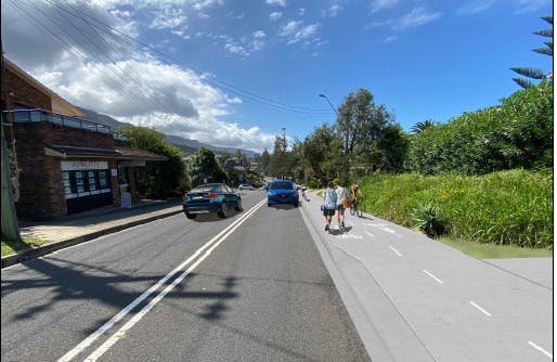 Grand Pacific Walk Austinmer - View to the north
-
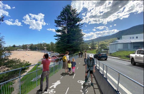 Grand Pacific Walk Austinmer - view to the south